










Three of the most iconic landscapes in the Argentine Andes have just received one of the highest honors in the earth sciences.
The International Union of Geological Sciences (IUGS) has added Aconcagua, the Campo de Piedra Pómez and the Fitz Roy plutonic complex to its official list of 200 Geological Heritage Sites around the world.
The designation affirms that these formations hold physical records essential to reconstructing the evolutionary history of the planet.
The announcement places Argentina among the South American countries with the greatest concentration of recognized natural laboratories.
The selection process weighed hundreds of nominations submitted by specialists from across the globe. Priority went to outcrops that lay bare tectonic, volcanic and magmatic processes that elsewhere remain buried beneath miles of crust.
Aconcagua as World Geological Heritage: the Collision of Tectonic Plates
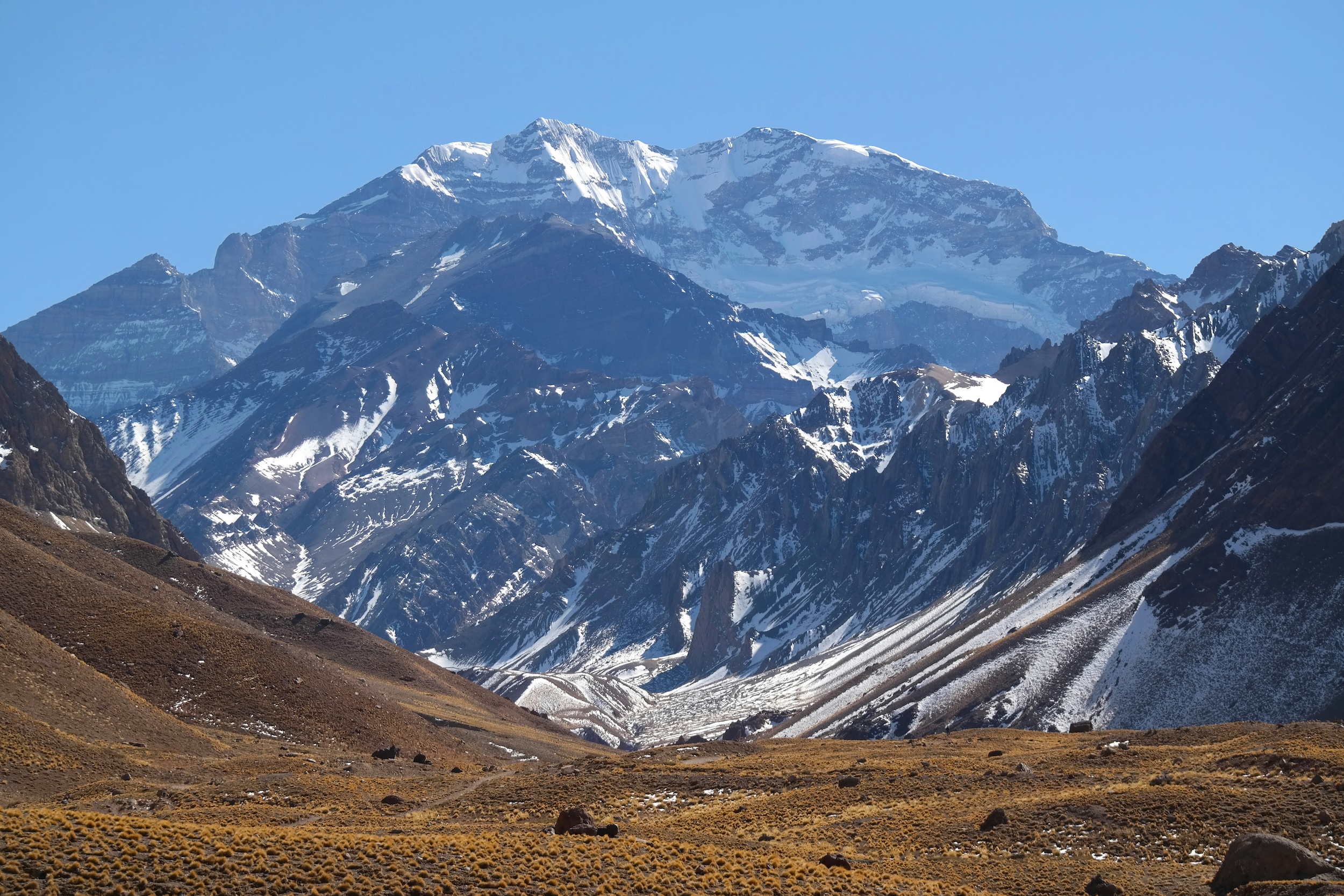
Rising from the province of Mendoza, Aconcagua reaches 22,837 feet above sea level, making it the highest summit in the Americas and in the entire Western Hemisphere.
The IUGS cited the mountain’s exceptional exposure of subduction between the oceanic Nazca Plate and the continental South American Plate, a process that unfolded roughly 15 million years ago during the Miocene.
Unlike other Andean giants that began as active volcanic cones, Aconcagua is the product of the stacking and folding of ancient sedimentary and volcanic rock.
The tectonic collision drove layers of seafloor and old lava flows skyward, creating a fold-and-thrust belt that geologists around the world use as a model for understanding how great mountain ranges are born.
Put simply, the tallest mountain in the Americas did not emerge from a fire-spewing crater. It was raised by the immense force of two plates pressing against each other over millions of years.
What now crowns the Mendoza sky at nearly 23,000 feet was, in the distant past, the bed of a prehistoric ocean, folded and lifted toward the clouds.
Its sheer walls, carved by Quaternary glaciers, make the faults that once deformed the Earth’s crust visible to the naked eye.
The arid high-mountain terrain, dominated by ice penitentes and slopes of gray and reddish scree, lays bare the long history of the Andean uplift with no vegetation to conceal the fractures in the rock.
There, in the mineral silence of the summit, the mountain keeps intact the memory of a planet still moving beneath our feet.
The Campo de Piedra Pómez and the Megaeruptions of the Puna
In the Antofagasta de la Sierra department of Catamarca province, the Campo de Piedra Pómez spreads across more than 185,000 acres at an elevation above 9,800 feet.
The scientific commission singled out the site for preserving untouched traces of an explosive volcanic episode some 70,000 years ago, linked to the collapse of the Cerro Blanco volcano’s caldera.
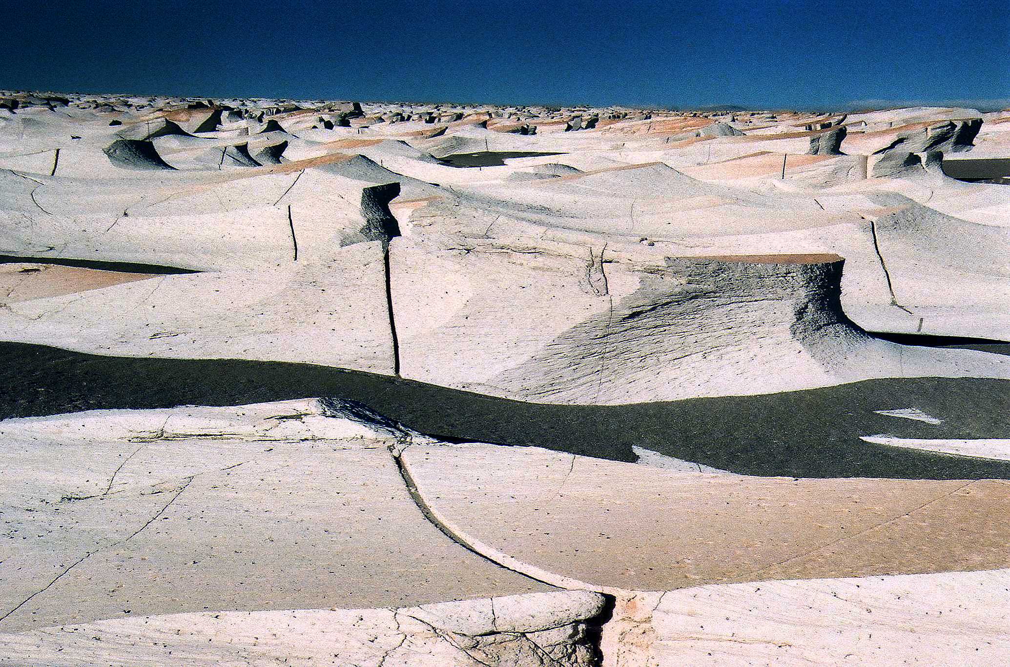
During that cataclysmic eruption, incandescent pyroclastic flows buried the basin under ash and pumice more than 330 feet deep. Over the millennia, the relentless katabatic winds of the Puna carved the soft, porous rock into thousands of elongated ridges known as yardangs.
The result is a natural labyrinth of white and ochre forms that resemble waves turned to stone in the middle of a high desert.
The Puna’s extreme aridity has spared the ignimbrites from chemical weathering, allowing scientists to study the dynamics of continental supereruptions and wind erosion under conditions much like those on the surface of Mars.
The Fitz Roy Plutonic Complex in Southern Patagonia
At the country’s southern edge, within Los Glaciares National Park in Santa Cruz province, the Mount Fitz Roy massif, also known as Chaltén, earned recognition for exposing the inner workings of a solidified magma chamber.
The plutonic complex is roughly 16 million years old and offers a textbook example of how magma rises from the depths without ever breaking the surface as lava.
The pale granite that forms the main spires cooled slowly beneath miles of dark host rock, creating an intrusive body known as a pluton.
Later, the uplift of the Patagonian Andes and the advance of vast, grinding ice fields stripped away the overlying layers, exposing sheer walls of crystalline rock more than 11,000 feet high.
The visual contrast between the silvery-gray granite of the magmatic core and the dark sedimentary rock surrounding its base reveals the precise boundary where molten magma forced its way into the crust.
The razor-edged spires, battered by Pacific winds and crowned with hanging glaciers, serve as an open cross-section of the Earth’s interior.
Scientific Preservation in the Face of Environmental Pressure
Inclusion in the IUGS registry is more than a mark of academic prestige. It carries an international commitment to protect the physical integrity of these three sites against climate change and human activity.
Accelerating glacial retreat in Mendoza and Santa Cruz, along with growing tourist traffic across the fragile volcanic soils of Catamarca, demands strict monitoring protocols.
The geology of these three places shows that the present face of South America is little more than a snapshot in an ongoing cycle of building and wearing away.
From the ice of the central Andes to the ash of the Puna and the granite of the far south, Argentina’s crust preserves the clearest pages of the planet’s mineral memory.