



For nearly 500 years, most of us grew up looking at the same map of the world without giving it much thought.
On Sept. 4, 2026, the United Nations General Assembly decided it was time to reconsider it.
The U.N. voted to endorse a new world map that shows the true size of the continents, after African nations argued that the traditional map had long made them look smaller than they really are.
The result was lopsided: 164 votes in favor, 6 abstentions, and just one against — cast by the United States.
What the General Assembly Actually Voted On
The resolution, titled “Correct the Map,” is not legally binding on any country or institution.
Instead, it invites governments, schools, and technology companies to consider replacing the Mercator map — the projection that has dominated textbooks, atlases, and digital platforms for centuries — with alternatives that more accurately reflect the relative size of each continent.
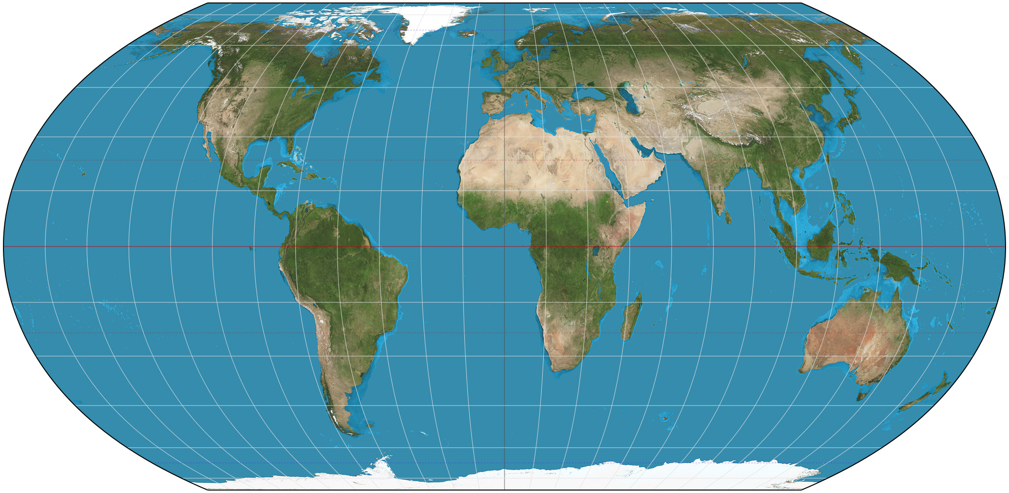
Among those alternatives, the resolution specifically names the Equal Earth map, published in 2018.
The initiative didn’t come out of nowhere. The African Union formally adopted the Equal Earth map in March 2026, and in April tasked Togo with leading a campaign to bring the issue before the U.N.
The campaign also drew support from a Change.org petition under the hashtag #CorrectTheMap, which gathered roughly 11,000 signatures before the vote.
The Mathematical Problem Behind the Map We All Know
The Mercator map wasn’t created with any ideological purpose.
It was designed by Flemish cartographer Gerardus Mercator in 1569 for a very specific reason: to let sailors plot compass routes as straight lines on a flat surface.
To do that, Mercator sacrificed accuracy in the size of landmasses in order to preserve exact angles and directions — something essential for navigation at the time.
That mathematical trade-off has a side effect that intensifies the farther a region is from the equator. Regions near the poles appear far larger than they actually are, while regions near the equator — home to much of Africa, Latin America, and Southeast Asia — appear compressed.
The most frequently cited example is Greenland, which on a Mercator map appears nearly as large as the entire African continent. In reality, Africa is fourteen times larger than Greenland.
This Isn’t the First Time the Debate Has Come Up
The argument over which map is the “correct” one goes back nearly fifty years.
In 1974, German historian Arno Peters introduced a projection that rendered land areas in their true proportions, though it significantly distorted the shapes of the continents.
It later emerged that an almost identical projection had already been described by Scottish cartographer James Gall in the 19th century, which is why it is known today as the Gall-Peters projection.
Peters made an explicitly political case for his map, arguing that the Mercator overrepresented colonial powers and skewed the world’s image in their favor. Colonial cartography left other marks on Africa’s map, including the borders that left Bir Tawil unclaimed.
The cartographic community reacted with considerable skepticism, and several experts accused Peters of recycling someone else’s idea to promote himself.
Even so, organizations such as UNESCO, UNICEF, and Oxfam adopted his map in various materials, and the controversy even made its way onto television. A 2001 episode of “The West Wing” featured a fictional advocacy group campaigning to have American schools replace the Mercator with the Gall-Peters.
In 2017, the Boston public school system became the first school district in the United States to officially adopt the Gall-Peters in its classrooms, as part of a declared effort to teach its curriculum through a less Eurocentric lens.
Equal Earth, the Alternative the U.N. Now Endorses
The map backed by the new U.N. resolution isn’t the Gall-Peters, but a more recent one.
Equal Earth was created in 2018 by cartographers Bojan Savrič, Tom Patterson, and Bernhard Jenny, with a clear aim: to preserve the accurate proportions of the Gall-Peters while correcting the distorted shapes that the cartographic community had criticized for decades.
The result is a projection that shows the true relative size of the continents without the stretched, unnatural shapes that defined its predecessor.
Why the United States Voted Against It
The U.S. representative to the U.N. was the only one to publicly oppose the resolution during the vote.
She argued that the body should focus on matters of international peace and prosperity rather than debating a 16th-century mapmaking dispute, and described the initiative as part of an agenda that, in her view, undermines the U.N.’s credibility.
Togolese Foreign Minister Robert Dussey defended the resolution, arguing that no map is neutral — that from an early age maps shape how people understand where every nation and continent fits in the world.
Months earlier, African Union Commissioner Amma Twum-Amoah had argued that Africa deserves to be seen at its true scale — geographically, historically, and culturally.
What Actually Changes From Here
In practical terms, not much — at least not immediately.
Because the resolution is non-binding, no government, school, or technology company is required to swap the Mercator for the Equal Earth — and no one is barred from continuing to use the traditional map.
What the vote does do is put the issue on the U.N.’s official agenda and give formal institutional backing to a cause that until now had been confined largely to cartography specialists and awareness campaigns.
Whether schools, media outlets, and digital platforms actually adopt the new projection in the years ahead will depend — as it usually does with symbolic resolutions like this — on the choices each country and institution makes, not on any global mandate.
What’s clear, half a millennium after Mercator drew his first map, is that how we picture the world has never been a purely technical matter.