
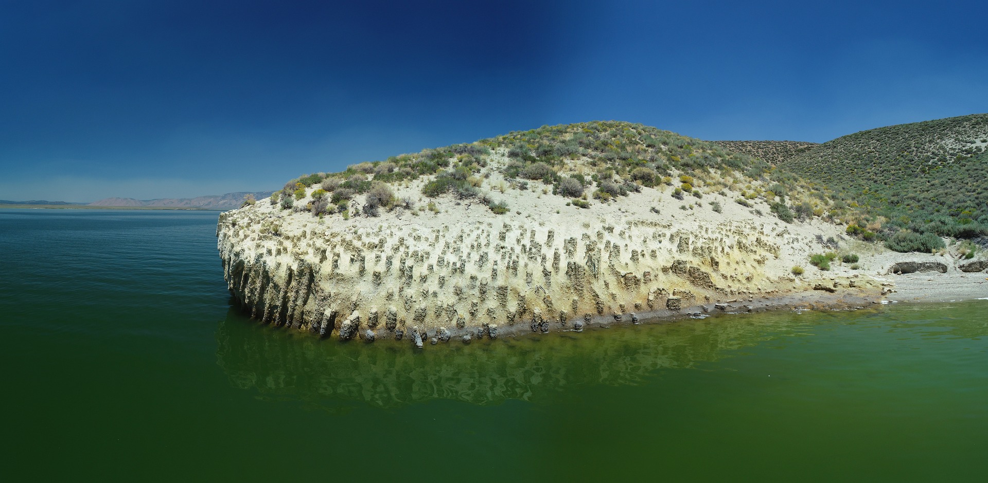
On the northeastern shore of Crowley Lake in eastern California, nature created something that stops people in their tracks: hundreds — thousands, by some estimates — of stone pillars arranged in rows, arches, and corridors that evoke the colonnades of a ruined temple.
The site, known as the Crowley Lake Columns, is one of the most extraordinary formations in the Eastern Sierra. Despite growing attention on social media, it remains a destination that rewards those willing to make the effort to reach it.
An Origin Story That Begins With a Supereruption
The story of these columns begins roughly 760,000 years ago.
At that time, the Long Valley Caldera produced one of the most violent eruptions ever recorded in North America — releasing a volume of volcanic material thousands of times greater than the 1980 eruption of Mount St. Helens.
The explosion buried the surrounding region under a thick blanket of rhyolitic tuff, a rock formed from compacted ash and pumice.
For years, geologists debated how that ash layer eventually formed into such precisely defined columns.
The explanation now supported by much of the geological community — including researchers at the University of California, Berkeley, who analyzed samples using electron microscopy and X-ray diffraction — points to a process that unfolded after the eruption itself.
According to this model, water, possibly from melting snow, seeped into the still-hot volcanic deposit. It generated steam and triggered a pattern of regular fractures within the tuff. Dissolved minerals then filled and hardened those cracks, creating structures far more resistant to erosion than the surrounding rock.
Over millennia, wind and water wore away the softer material until only that skeleton of columns remained — many of them hexagonal, rising to nearly 20 feet.
The lake that surrounds them today is far more recent. It formed in 1941, when the Los Angeles Department of Water and Power built the Long Valley Dam across the Owens River to secure the city’s water supply.
The reservoir’s fluctuating water levels, combined with accumulated erosion, gradually exposed one of the most unusual geological formations in the American West.
How to Get There
The columns sit on the northeastern shore of Crowley Lake in Mono County, a little more than 15 minutes by car from Mammoth Lakes and just over an hour from the western entrance to Yosemite National Park. The lake lies alongside U.S. Route 395, the main corridor running through the Eastern Sierra.
Getting to the columns, however, is not straightforward. There is no parking area beside the formation and no paved path leading to it. Visitors generally have three options:
- By high-clearance or 4×4 vehicle, following dirt tracks that skirt the lake to a drop-off point, then continuing on foot down a slope of loose earth and sand.
- On foot, a slower approach but one that avoids the risk of getting stuck on rough terrain — the better choice for anyone without a vehicle suited to unpaved roads.
- By kayak or small watercraft, launching from the boat ramp when water levels allow. Many of the lower columns remain partially submerged during snowmelt season.
It’s essential to check reservoir levels before planning a visit.
In spring and early summer, water typically covers a significant portion of the lower columns. By late summer and fall, the receding lake exposes a far greater section of the formation — making those months the best window for exploring on foot.
Because this is a natural site with no tourist infrastructure, there is no official signage and no services on site. Visitors are strongly advised to bring water, sun protection, and sturdy footwear for the descent.
Geologists who study the area ask that visitors refrain from climbing on or leaning against the columns. Despite their solid appearance, the material is porous and fragile, and repeated foot traffic speeds up their erosion.
What Else to See Nearby
The Crowley Lake area makes an excellent base for exploring other landmarks along the Eastern Sierra:
- Mammoth Lakes, just over 15 minutes away, offers the alpine lakes of the Mammoth Lakes Basin, year-round mountain activities, and a full range of visitor services.
- Hot Creek Geologic Site, with its thermal pools and a canyon carved by volcanically heated water, sits very close to Crowley Lake.
- Devils Postpile National Monument, another spectacular example of columnar basalt formed by cooling lava, is located near Rainbow Falls.
- Convict Lake, a mountain lake ringed by jagged peaks, is well suited to short hikes with sweeping panoramic views.
- Mono Lake, farther north, is celebrated for its otherworldly tufa towers rising from the water — yet another volcanic landscape unique to this corner of California.
Between fishing, water sports on Crowley Lake itself, and these nearby excursions, there’s enough here to easily fill a multi-day itinerary through one of the most geologically active — and visually surreal — corners of California.