
A few blocks from the crowded boardwalk of Venice Beach—where skaters, street musicians, and tourists with phones raised jostle for the same patch of ground—sits a neighborhood that feels like it belongs to an entirely different city.
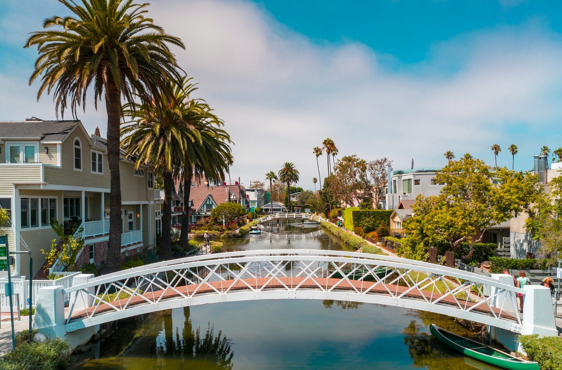
Six quiet waterways cut through it in near silence, flanked by houses with small private docks, ducks gliding between tethered kayaks, and wooden footbridges arching over the water.
There are no gondoliers. But the resemblance is unmistakable. That was always the point.
The Man Behind the Project
Abbot Kinney was born in New Brunswick, New Jersey, in 1850.
He made his fortune in the tobacco industry and first came to California at the age of thirty, drawn in part by the climate, which offered relief from his chronic asthma.
He was a man of considerable wealth and grand ambition, with a taste for European culture, though the land he eventually acquired was little more than a muddy coastal marsh.
How he came to own it reads almost like a comedy of errors.
Kinney had been a partner of Francis Ryan in the Ocean Park development, the precursor to what would become the Santa Monica Pier.
When Ryan died suddenly in 1898, Kinney had no interest in continuing the venture with the investors who bought out his partner’s share. He sold his stake and turned his attention to the undeveloped wetlands to the south.
What he acquired was, by any measure, a swamp. To most developers of the era, it was a liability. To Kinney, it was the raw material for something grand.
With the image of Italian Venice fixed in his mind, he dredged the marsh to create canals and built Venice of America around the perimeter of a large lagoon, where Windward Circle now stands.
Mule teams did the initial digging in 1904. When the pace proved too slow, Kinney brought in steam-powered excavators.
The Fourth of July, 1905
On July 4, 1905, the seven original canals stretched nearly 2 miles. It drew between 40,000 and 50,000 visitors on opening day.
Kinney had imported gondolas from Italy and hired gondoliers to pole them through the waterways.
The complex included an auditorium, a ballroom, a ship-shaped restaurant, a saltwater swimming pool, and a Venetian-style facade facing the ocean. A miniature railroad completed the internal transit system.
What Kinney envisioned was closer to a cultural center than an amusement park. He wanted theater, art, lectures. What the public wanted was entertainment.
By 1909, his vision had given way to popular demand and Venice of America had become a full-fledged amusement park, complete with mechanical rides and commercial vendors.
It was not exactly the Venice of the Pacific that Kinney had imagined, but every weekend it packed the streetcars arriving from downtown Los Angeles.
What the Automobile Destroyed
Kinney died in November 1920, just as the automobile was beginning to reshape American cities. What followed could not be undone.
In 1924, the then-independent city of Venice decided to adapt its streets for the automobile age.
The corridors of the two Pacific Electric streetcar lines running through the city would be widened and paved—fittingly, they are called Pacific Avenue and Electric Avenue today—and the canals would be filled in and converted to streets.
Residents did not take this lying down. Those who lived along the canals feared losing the value that came with waterfront property, and many in the community questioned the logic of keeping the name Venice without any canals.
Property owners also challenged a special tax levied on them to fund the conversion. The legal dispute dragged on for four years.
By the time the courts finally ruled in favor of the municipality, Venice had already been annexed by the city of Los Angeles, which moved forward with the controversial plan to fill in the canals.
On July 1, 1929, when the first dump trucks unloaded earth into Coral Canal, it was clear that California’s Venice had lost its battle to the asphalt.
The seven original Kinney canals were renamed as streets.
Lion Canal became Windward Avenue, Grand Canal became Grand Boulevard, Coral Canal became Canal Street, Cabrillo became Cabrillo Avenue, Venus became San Juan Avenue, Altair became Altair Street, and Aldebaran became Market Street.
Anyone walking those streets today has no way of knowing they are walking above what was once open water.
The Six That Survived
The six canals south of Kinney’s original network survived for a reason that had nothing to do with sentiment: there simply were not enough residents nearby to generate the tax revenue needed to pave them over.
A bureaucratic oversight saved what decades of community attachment had not.
But survival was not the same as prosperity. After annexation, the remaining canals were largely ignored, and by 1940 they had fallen into complete disrepair.
With no funding and no political will to restore them, they stayed that way for more than four decades.
By the 1950s, the area was known informally as the “slum by the sea”, and its low rents attracted Beat poets, artists, and countercultural figures throughout the fifties and sixties.
The canals, meanwhile, accumulated layer after layer of sediment.
The 1990s Restoration and the Price That Followed
In 1993, the canals underwent a six-million-dollar renovation that drained them, dredged out eighty years’ worth of accumulated silt, and restored the footpaths and pedestrian bridges.
The district had been added to the National Register of Historic Places in 1982 and designated a Los Angeles Historic-Cultural Monument in 1983, but it was the restoration that triggered the neighborhood’s dramatic transformation.
What followed was one of the steepest rises in property values in the city’s history.
In 1985, a property along the canals sold for around $150,000. Today, buying a home in the area costs well over a million dollars.
The median sale price in the canal district surpassed $5.1 million in the most recent available records, with a price per square foot among the highest in Los Angeles.
Gentrification accelerated sharply during the 2000s and 2010s, as technology companies moved into the corridor known as Silicon Beach.
Historic homes were demolished to make way for modern construction, and the neighborhood became a magnet for tech workers and high-income creative professionals.
Today, the six surviving canals—Carroll, Linnie, Howland, Sherman, Eastern, and Grand—run through one of the most expensive residential neighborhoods in California.
Water enters through gates connected to Ballona Lagoon and the Marina del Rey breakwater. The gates open at low tide to drain and close at high tide to retain water for roughly three days before it is replenished.
There are no gondoliers. No miniature trains. But the ducks and the private docks remain.
And so does the strange sense that someone, more than a century ago, bet everything on a wild idea in the middle of a swamp.